Chapter
Two
Payette
to Central Time Zone
It was very hot the whole time I was in Payette, the English would say "Bloody Hot!"
(92-97º daily). Monday morning 07/01, it was 8:08AM and time to go. I was careful to get everything packed, battery charger (camera batteries), toothpaste, shaver etc. etc. I was gone'n a wave.
Pulled in for gas at Cambridge ID having planned to eat at Kay's Cafe, a spot Pat'n I found two years previous. Kay's is closed on Mondays...DAMN! Press on. Took a couple of pictures from the saddle as I moved along. So much of Idaho is Snake River Valley - which is nothing to see - fertile desert would be my description. However, going north, US #95 starts to get real pretty about Cambridge.
 US#95 N. of Cambridge UT
I'm conscious of climbing now and the temperature is dropping a little. I may want to put my jac- OH MY GOD! I left my jacket on the chair back at Roy's. It was 9:56 AM when I pulled-up in New Meadows and made a bee-line for the phone. Roy was asleep (DUH!), but Jan took the information... Yes, they'd mail my coat ahead to my next known destination, the Bohn Residence in Brainerd MN. I was asked, "What would I do in the interim?" If necessary, shop a thrift store for a suitable 'throw-away' jacket. Time was not an important issue here as we weren't scheduled to leave Brainerd until the morning of 7/7 and so far, I didn't need a jacket unless moving at high elevation. Problem solved. Had breakfast and put-on long-sleeved wool-blend shirt - plenty of warmth.
I'm riding along and lose an hour due time-zone change, stop at a nice highway rest area just south of Riggins, the Sheep Creek Rest Area. Rode on through Riggins and passed (reluctantly), the turn-off for the little community of White Bird. White Bird sat at the base of White Bird Pass, a motorcyclist coveted 15 miles of switch-backs. I was fortunate enough to have ridden White Bird when it was the main-route, now supplanted with a super highway with a steady but super grade. Two-thirds of the way up is a rest area created and maintained by the Nez-Perce Indians, one right over a very famous battle wherein the white man lost. Took pictures of the battlefield and of the explanatory displays.


U.S. History Lesson Here White
Bird Pass - the old road in distance

 Signs at the
battlefield, fought at the bottom of White Bird Pass (old one!)
 Center section, between signs above.
I'm rolling down the north side of White Bird Pass and get a beautiful glimpse of the Camas Prarie, rolling hills of wheat, hay and alfalfa. Get out the camera Chris! Well the camera is kept in the gas tank pack, just let go of the bars (you can ride safely with no-hands), get-out the camera, turn it on, hold over your head and OH MY GOD THAT'S A STATE TROOPER COMING AT ME! He pulls into a turn-out in a cloud of dust as I pass. Oh shit! Yeap! Sneak the camera away... The lights come on and I move over and start to slow down for a 'minimal talk' when he zooms on past. Whew! A Camas Prairie picture was thus had, just not the preferred photo. A little later I pass him again, only now he's engaged in a traffic stop and didn't so much as give me a dirty look. I figured I ducked that bullet!

Camas
Prairie (taken on the move..signs always get in the way!)
It's 1:10 PM when I roll into Kooskia on Idaho Hwy. 13 (left Hwy. 95 about 20 miles back, at Grangeville). Idaho Hwy. #13 is very steep, curvy and scenic. Kooskia is a small community that 'anchors' the Idaho end of Lolo Pass, and it's my place for gas'n cigars as there are no services to speak of on Lolo Pass. Ice 'n lighter flints needed too! (Love those Indian tobacco stores...). The Montana-end of Lolo Pass is anchored by...are you ready? Lolo, about 10 miles south of Missoula. It's about 105 miles Kooskia to Missoula. Lolo Pass, US Hwy#12, follows two different rivers for most of it's distance, they are both wild rivers and favorites of rafters and kayakers.


Little 'dot' above whitewater
above, is Lochsa R. (from saddle)
helmet (see next)


Kayaker with his dog I didn't kill all bugs - it just
seems that way
One of the rivers, the Lochsa, has some one-person kayakers in rough water and I stop to watch - it's 2:10 PM I take a couple pics and later help one up the bank pulling his boat up. These guys are river guides (12-15 man inflatable boats) and on their day-off, go shoot the waters in their one-man boats, each trying to out-do the other. I asked why each was going out into the fastest, most dangerous part of the stream and paddle against the current. The fellow gave me a wink and said they were perfecting their 'show-off skills'. I was told that they will later move into the Smokey Mountain area waters and carry-on their business there. One of the fellows down on the water asked me to release his dog from the back of his truck and the dog was very soon into that fast moving water too. I took yet another picture.
My 'plan' called for me to ride the collection of state highways East, using the '200' designation. I've ridden Hwy. #200 from Sandpoint toward Missoula a couple of times, some of the prettiest scenery anywhere. And, I'd ridden some of Hwy. #200 east of Missoula, but not much. Pat'n I passed-through Lincoln Montana, the Unibomber's 'home-town' shortly after his capture several years ago and laughed heartily over the sign at the general store there, it said: 'Official Outfitters of the FBI".
Rolled through Missoula on expressways enroute to Interstate 90, which I needed to pick-up, to find MT Hwy. #200. In doing so I passed a Chinese restaurant - then my nose caught the smell - that was it. It was 5:04 PM, China House for dinner! No Beef Chow Fun - damn! But I ate well so don't feel to to sorry for me!
Up onto Interstate #90 EB and quickly off for MT #200 EB. I gassed in Bonner, just outside Missoula at 6:12 PM Lincoln was just 73 miles down the road or so the sign said.


Along MT#200 (poles or
signs-sigh!) First Camp - Lincoln MT
(self portrait)


Gas Tank Pack/Saddle
Cushion-'musts' Clean clothes
ready for the AM
It was about 7:30 PM when I arrived in Lincoln and made a bee-line for a phone to call Pat. I was informed that benches that I'd purchased for the church (before leaving) were now all up'n assembled. Also, that she'd heard from Roy and knew about my 'jacket flap', passing-on that it had been 'UPS'd' to Brainerd already. I drank some fluids walked around and set-off to find a Forest Service Campground that a local said was just seven miles down the road. However, on leaving town I look over to the right and there are a couple of motor homes in a park-like setting and turned around. No hook-up camping was $6.00. I didn't quite have $6. and nobody was there to make change. Came-up with some $5.63 and wrote on the payment envelope to 'see me'.
Nice facility! Set-up camp, lit a cigar (one from Herb Stuart - my retired Dentist-friend), made a drink, brushed my teeth and then set-up camera and tripod. I took a picture of me sending Bea Stuart a postcard, something I promised her I would do on a daily basis. Very soon it was 'nite-nite time'.
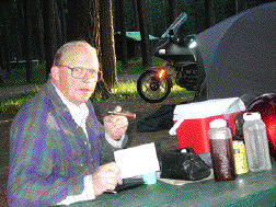
Herb's
cigar, note whisky, mixer Bea's card
Wow! Up'n awake just after first light. Cool! (No, really, it was 46º). Found my way back into town for the Post Office and mailed off Bea's card and some others. And, in the process found an open cafe. Let's eat! (Also gives the sun some time to rise!). Eat-up, nursed my coffee and wrote some more post cards. I'd brought along a 'truckload' of historical Pacifica postcards which were made'n sold as a fund-raiser for the local Historical Group (12 for a Buck!), and the way I go through cards a real money-saver.
I'm wearing my wool-blend long-sleeved shirt in lieu of my jacket (then e/r to Brainerd via Fed-Ex or UPS remember...). I pulled through town and headed East on Highway 200. My plan called for me riding the collection of state-route 200's all the way into central Minnesota. It was a plan...turned-out to be a damn good plan, too!
So, now I'm tucked behind the windshield, the temperatures are rising and I'm really not uncomfortable. Traffic is all but non-existent and I roll into Great Falls MT for gas. I hadn't been asked to shift to reserve but the fact that I needed 4.119 gallons of fuel told me I was 'there'. Gas? Cheap, only $1.57/gal for 'super'. It's 9:38 AM. Enroute I stopped to read two historical markers, about early calvery and miner 'doings', and learned the importance of the Sunriver Bridge which I'd just crossed (the fourth incarnation since 1836).
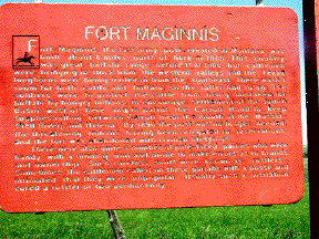
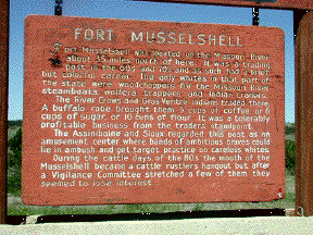
Montana historical signs are funny and
informative!
It was 11:30 that same morning when I paused in Moccasin MT, a real honest-to-goodness ghost town. I found a working Post Office here but a community of abandoned buildings. It was both erie and beautiful. Yes, took some pics while there.
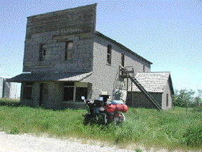
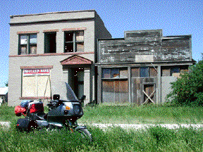
These
buildings in Moccasin are across the street from each other.
Bank
failed in 1922
I'm gassing and 'breaking' in Winnet MT at 1:18 PM. Needed to, took-on just over 4 gallons of petrol. This is THE BIG SKY country alright, horizons are low, country fairly flat, ergo lots'o sky. But it's hot!
I roll into Jordan Montana, a place I later learn is Carol Bohn's description of the 'tail-end' of the universe. Jordan's claim to fame is that it's right in the middle of the area wherein rare and unusual fossils are unearthed. Tyrannosaurus Rex was first unearthed in this neighborhood. I needed ice'n human contact so I ducked into a corner bar, one block off the 'highway'. Interesting! I got some free ice for the cooler, a couple of on-tap 7-Up's. The back-bar was quite an affair and I learned that it was in use at Fort Benton (the Montana Territory 'capital') before being moved to Jordan. During my stay and chit-chat met a local who was a long-haul trucker who urged me to take a detour off Hwy. #200, this at Halliday ND.
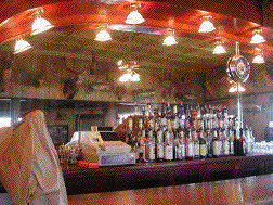
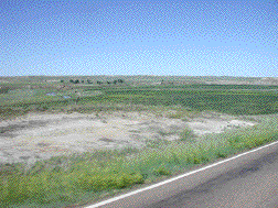
The bar in Jordan Montana This is why it's
called 'Big Sky Country'
By 5:16 PM I felt I'd had a full day and I roll-into and gassed in Circle Montana. The very first building in town was a large, muti-building, local historical museum which was already closed. The proprietor at the gas station was a motorcyclist and in response to my questions told me of their City Park where I was welcome to camp, free no less! I was already starting to like Circle a whole bunch. The gentleman gave me directions.
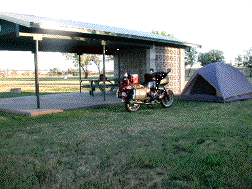
Well, I found the park! Here's this little town out'n the middle of no wheres-ville Montana and the park is huge! I counted five baseball diamonds, four tennis courts, swings, slide-sets everywhere, and a swimming pool. The park was covered with covered concrete pads for picnic tables. I put-putted all over the park looking for the camping area and couldn't find it. So, I start my 'loop-drive' again as I saw a park worker fixing one of the benches. I stop, park, and walk over to this 'worker'. Worker hell! He's the Mayor of Circle Montana. Yes, I'm welcome to camp, any damn place I please. He suggests that if I used the shelter he's then working under I'll have both running water and electric lights.
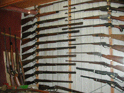
Met Circle's Mayor-Right here! Part of the Circle Museum's Gun Collection
We talked and talked. I learned that he is a 'soils engineering consultant' when not doing civic duty; that the town has some really serious water issues that it must deal with. Town wells (2) are currently 1500' deep but the water has seriously excessive amounts of fluoride and a bacteria which is every expensive to treat (we're talking thousands of dollars for a town with a population of 624 souls). Circle has two paid full-time employees, one of whom is the Police Chief who was then on suspension for 'Valium Abuse' (this without a prescription), and he was having the State Attorney General conduct the investigation. Seems the Chief had to be rushed hundreds of miles to a hospital for what turned-out to be an overdose situation. The Mayor told me that the psychological work-up had ruled-out depression or attempted suicide and was I looking for work? NO!
I learned that Circle had two restaurants, the 'preferred' was closed for the owner's holiday leaving me a choice of 'Tastee Freeze', or 'Tastee Freeze'. Gee! Where o' where will I eat? Well, for $8.10 I got a chicken filet sandwich with dinner salad, coffee and butterscotch milkshake. I'd live another day after all.
Cocktails were served back at camp - it was all set-up before I left for dinner. Cards written under electric lights.
Early in the morning on 7/03 I was awakened by two crop dusters. By 0730 hrs. I'd broken camp (along with the snake-fly zipper on my tent...damn!). Too early for the museum to be open so it's back to Tastee Freeze for breakfast. By 10:05 I'd done the museum, been to the Post Office (mailed cards and bought stamps), and was 'on the road again'.
The museum had some interesting exhibits all nicely done. Walls of rare and unusual (at least to me) firearms, a room devoted to local brands and some comical exhibits. One such exhibit was adjoining a collection of old watches and jewelry and announced that they did watch repair too! With a 50# wrench? Another, in the 'Natural History' section, where there were dioramas, stuffed animals and the like, was a 'collection of bones' all glued together to make up the skeletal remains of a non-existent creature - you'd only have caught the humor if you were paying attention. Pictures? Sure...
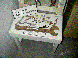
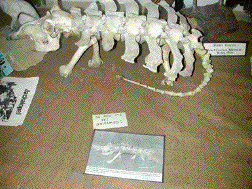
Humorous displays among the serious. Bones are just a 'collection'
It's 83º when I dismounted in downtown Sidney Montana at 11:15 AM, a 'state-line town', so said the Bank's illuminated sign. I needed a stretch and a drink from the cooler. Enroute from Circle I saw three deer, lots of horse flesh and no antelope. I re-mounted, the banks' sign said it was now 84º. Fairview is just a couple miles up the road, sign there says 85º and at 11:45 AM I entered North Dakota.
It's 12:05 when I find the City Limit sign for Alexander ND. I had previously noticed a sign touting the Lewis'n Clark Museum in Alexander and here the museum is the first building I come across on my way into town. I pull-up to the museum, the only other vehicle in the parking lot is a father-son duo on a new Honda Valkrie. We talk briefly. They were impressed with the museum. The building is the old high school and I pony-up the $$'s to visit. Well, you can't go back! This museum had very little material that related to Lewis and Clark (couple items in a little downstairs room), and it couldn't even begin to compare with the museum in Circle MT visited early that morning. Okay, I was spoiled early on....
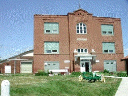
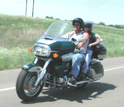
Lewis'n Clark Museum, Alexander
ND Rick and Cameron (father/son)
Moe
I clear the museum and find my 90º turn to the south at Watford, where an illuminated sign said it was 86º. I drive through town just to see it and pass the father-son duo on the Valkrie. They follow me into a gas station and we speak again. They are Rick, and (son) Cameron, Moo from Williston, ND. Rick is a divorced father and stock broker who was currently taking leave of the business. This was a 'quality time' outing for father and son. They were headed down to the Teddy Roosevelt National Park (which my route 200 passed), and did I wish to join them for a park 'tour'. Why not?
This National Park is divided into two sections, separated by about 35 miles of highway. Each part is accessible only by dead-end road. The northern section was the larger of the two and we rode in, paid our fees and proceeded up the rim of the valley created by the Little Missouri River which looked to me like a collection of connected mud-puddles, yet everything was very green. Our ride to the rim was fun, we saw Buffalo and once up on the rim the land there reminded me of the Camas Prairie that I left back in Idaho. Got lots of Buffalo pictures.
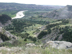
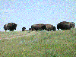
T. Roosevelt Nat'l Park; river is the Little Missouri, lots of wild Bison