2005's Decent Ride
Lima Ohio via Missoula Montana
Having enjoyed motorcycling all my adult life I was looking forward to this year's BMW Owner's of America and their yearly 'National Rally'. The Rally is held in a different location every year, last year we were in Spokane. Our 33rd annual gathering for this year was slated for Lima Ohio, a location that provided me with a decent ride. I enjoy these gatherings as much for the ride to and fro, as the actual gathering itself. Yes, I've attended most of previous rallies, including 'National #1' in Morgan Hill. Well, I went to Lima, logged-up 6,732 miles in the process and had some adventures along the way. This year was the first in which my wife Patricia did half the travel, having flown into Columbus Ohio, about 96 miles from Lima. She attended the rally with me and we 'moteled-it' coming home. I camped enroute to the rally where we shipped camping equipment home prior to our return departure.
Beginning Odometer Ending Odometer
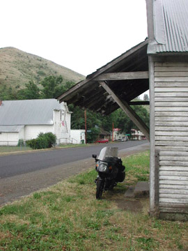
I rolled out of the house on the morning of 7/6/05, a Wednesday, this at 8:55 AM. The tank had 21 miles on it at the time and my odometer registered 59848 miles. My first destination was the home of a former partner in Payette Idaho, a decent distance from home. I knew from previous experience that I could reach Payette in one day if I hustled. I did! I gassed in Auburn, my first dismount since leaving home; that's a 133-mile 'sitting' which is a bit much but I needed to roll. I next gassed in Fernley NV after another 130 mile 'sitting', this at 1:09 PM.; this included a long stretch of 'lane-splitting' on Interstate 80 near the top of Donner Pass. Lane splitting is legal in my State but I'll only do it on rare occasion and this when traffic is at a near standstill. It was! The State Department of Transportation, 'Cal-Trans', was doing roadwork and we were all reduced to one-lane. An old, over-loaded pick-up truck pulling an equally loaded-up trailer stalled just before the traffic opened-up to two lanes. Had it been cool, instead of the mid 90º's, I might have sat in traffic but given the temperature and the air-cooled motor I was using, movement was in order. I Gassed and stretched in Fernley where I used the shade to cool-down and take a self-portrait.
This was the first and last time the cycle was loaded in this fashion.
I dismounted for lunch in Lovelock NV, as there's a casino there that historically puts-up the best Chef's Salad. Got my salad and paid a small payment to the bandits that abound in a casino. I cleared Lovelock at 3:05 PM for gas and a highway change in Winnemucca.
Better salad than it looks!
I run on 'super' whenever available and throughout this trip saw great fluctuations in the cost of fuel. Paid $2.65.9 per gallon in both Auburn and Fernley, but in Winnemucca it jumped to $2.73.9/gallon. I was doing well to make my destination as planned. You will note that this year, as in years past, I carry a small cooler as it's important to stay hydrated in such heat and it was HOT! The fact that I was wearing a motorcycle jacket (sans liner) was only a problem when stopped - I wore the jacket every mile on this year's jaunt - it is a safety garment.
Having cleared Winnemucca I was now headed straight north on US #95 with a planned stop at the NV/OR boarder (McDermit) and was south of that town about 35 miles when I passed a rather late model Cadillac with an elderly gentleman standing along side.
He looked at me so intently I suspected trouble and did a U-turn. He was stalled; had been for several hours and the battery on the car was now 'dead'. The man's wife was asthmatic, dehydrated, and in need of an electrical connection to run her 'machine'. They had called for a tow immediately on having stalled but several hours later, were still waiting. I delivered an unopened large, cold Gatorade and helped them flag down a Deputy Sheriff, who called the Nevada State Troopers. I stayed with them until the Trooper arrived and she was hooked-up with her machine in his air-conditioned cruiser, a Ford SUV. Well, there went some time!
Nevada State Trooper
I jumped back on the road for McDermit where I replenished my 'sport drink' supply, taking advantage of a price war between Gatorade and Coca Cola's Poweraide. Coke wants the business and were (are still perhaps?), underselling Gatorade by a meaningful sum. I next dismounted at Burns Junction where I tried to call Pat and my Payette host but found I'd lost the slip of paper with my phone card information thereon. I was given a 'go-phone' by my good friend and neighbor John Guy; it was time to use it. I called Pat, asked here to send the phone card information via e-mail to my host in Payette. The stalled motorist, and having entered the Mountain Time Zone, were taking a toll. I was back on the road for Jordan Valley Oregon and rolled-in on my 2nd reserve 'tank', 176.2 miles from Winnemucca gas. It was one of the few times I was forced into using that 2nd reserve the whole trip. Gas was cheap given prior experience, super was only $2.38.9 and I took on 5.694 gallons (that was cutting it real close!). My MPG was taking a real hit at high speed, not quite 31 MPG (vs. 40.23 MPG and 41.3 MPG for the first two 'fillings'). I had no cellular service in Jordan Valley, a location I'd previously agreed to call my Payette host from.
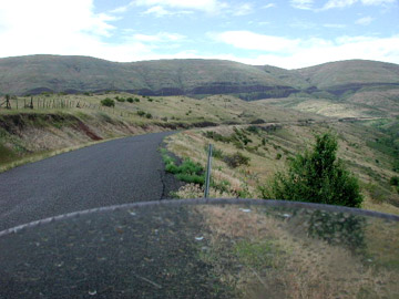
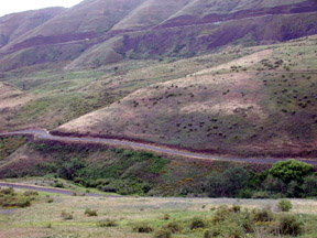
US Hwy.95 is fast, generally straight but does have some beautiful sights, the low sun and cloud shadows help.
Shadows and Light - US Hwy #95 near OR/ID boarder
The Idaho border was just ahead and six miles from said line I found myself riding alongside this little desert stream, very pretty and WHAT THE HELL!
Dammed if I don't spot a Beaver, a Beaver in the desert! Scrub Oak has to pass for a tree in this area, maybe a little Cottonwood. I make a U-turn and parked off the roadway from the pool in which I spotted the Beaver. I approach the pool with camera at the 'ready', using a large bush to cover my approach and I raise-up to snap my picture and that creature, using cat-like reflexes, dives. I got a picture, just not the good one I'd hoped for. Farm truck stops and it's the local property owner and his wife, he tells me he's taking down the Beaver's handiwork as fast as the latter can build as he needs the stream's water flow for his operation. We both marveled at the Beaver's existence in this location and wished it well.
Beaver's 'pond' - Looking both ways..
The 'shy critter' itself.
First town in Idaho on US #95 is Marsing and I had cellular service there, I called my host, Roy Hicks, a fellow retired San Francisco Police Lieutenant. I was good to go.
It was now 8:40 PM and the last light of day, I was an hour away. I rolled into Roy's driveway at 9:35 PM San Francisco time. I took 12 hours and 40 minutes to cover the 661 miles between our homes. I took a number of photos from the saddle during the process.
US Hwy 95 in Oregon (E/R Jordan Valley)
While in Payette Idaho Roy'n I played a lot of pool and did some dirty tasks for which company is always appreciated (e.g., installed new faucet and hose in the kitchen, dug-up rain-bird units in the yard for water feed repairs and finally solved an electrical dilemma for the dishwasher's power supply and the overhead lighting. When I tell you I was 'shocked' by all this, I was, 115 volts worth!
I'd planned on an early departure 7/10 so as to take in church services there in Payette, a church I'd previously visited two years ago. But, while packing-up the motorcycle one of the clasps on a saddlebag broke - a serious issue. Roy'n I spent all morning and two-trips over the state line into Ontario OR to get the tool and proper rivets with which to effect repair. It was fixed, but my early departure was now moved to 12:06 PM.
I wanted to ride, but I also wanted to eat - another real dilemma. I stopped in Cambridge, about 40 miles up US #95 from Payette and headed for Kate's, a place I was fond of from previous travels. Damn! Kate's is now 'The Gobbler', proving yet once again you can't go back! No, no need to return to the 'Gobbler' now...
Back on the road, Idaho just gets prettier as one moves north. The sky was overcast and threatening rain...it stopped 'threatening' just before I reached Whitebird.
This little community sits at the base of the pass which bears the same name and takes NB traffic out onto the high Camas Prairie. I paused in Whitebird, which today is almost a ghost town to have a smoke and wait-out the rain shower.
Whitebird used to be on the main highway and sat at the base of a very difficult chunk of highway. Today the new highway bypasses the town but I was looking forward to riding the old road which runs right through 'town'. Well, the rain wasn't letting-up, it hadn't cooled things down much (Damn!), and so it was time to jump into the rain gear and press-on.
Downtown Whitebird IFO old, abandoned storefront -it's raining.
Whitebird's old pass was a series of short-coupled switchbacks and I'm old enough to remember having ridden it once, many, many years ago when still the main highway. You didn't go fast as it was only two-lanes - when you caught up to a truck, there you were, stuck!
Going-up old Whitebird, new highway in the cut - far distance
Old highway in the foreground, new in the distance. Looking down old Whitebird
Whitebird's old route has been recently chip-sealed, smooth but with some gravel patches. That, coupled with the rain, dictated considerable 'caution'. Once over the pass (4450' elevation), you descended onto the high Camas Prairie with its rolling fields.
Camas Prairie
At Grangeville I leave US Hwy. 95, my route since Winnemucca. I turn onto a beautiful road, Idaho#13 that is only twenty-seven miles long. This road descends a steep canyon and follows a stream ending at Kooskia (pronounced 'Koose-key').
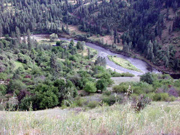
Along Idaho Hwy. #13, descending the canyon for Kooskia
I connect with US Hwy#12 and Lolo Pass. Gas is seemingly 'reasonable' in Kooskia at $2.59.9 a gallon for super and gas you must. There is only one opportunity to buy gas on Lolo Pass, at a resort near the top of the pass, otherwise it's Lolo Montana, 147 miles down the road. And, since there's an 'Indian Smoke Shop' next to the gas station I stock-up on some fresh cigars. It's 6:35 PM local time, recall that I left Roy's place at noon. I dined in Kooskia and left in search of the night's abode. My thinking was to ride-out onto Lolo Pass and find a campground. Just a few miles down the road I came upon what turned out to be a 'just stranded' motorcyclist who was headed WB, he'd run out of gas but carried a container. We exchanged pleasantries for a few moments before I swung back around EB in search of that 'abode'. Eureka! I found it just 23 miles from Kooskia, the Wild Goose, a USFS campground on the banks of the Clearwater; nice clean facility and only an $8. expense. I'd covered 234 miles for the 'late-start' day. I was almost to the start of the Clearwater, it commences just a mile further up the road where the Selway and Lochsa Rivers converge to form the Clearwater. The names are both Native American in origin, 'Selway' means something like 'calm water', while 'Lochsa', just the opposite.
I set-up camp, opened my refreshments and set about to write some postcards, an activity I like to engage when traveling alone. I can do this in part thanks to my 'camp light', an old, old motorcycle accessory designed as a trouble light but modified with 50' of cord and an in-line switch. Just plug it into the cycle, un-coil the wire and you've got lots o'light.
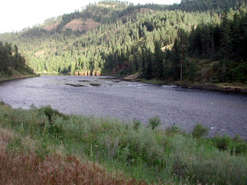
The Clearwater, runs alongside US Hwy #12 near Kooskia
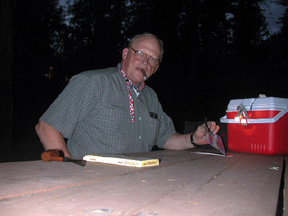
Note the light clipped to the cooler handle, light switch on top of cooler.
Who took the picture you might ask. I did, using a small two-piece tripod.1
I was up and on the road late the following morning as I rode just 28 miles before arriving at the USFS's 'Historical Ranger Station', a very old station that has since been turned into a museum for the Forest Service. I didn't arrive till just before Noon so you know it was a 'late-start' for me. I returned to the road after a brief respite and passed many motorcycles who too, were riding Lolo Pass.
I paused at the DeVoto Grove, a memorial to a man who spent his life studying the journals of Lewis and Clark. The man's ashes were spread here, a beautiful grove of Red Cedars; I paused to read a sign further up the road, about the coldest recorded temperature in the 'lower 48', -70º.
I didn't stop again until I reached the top of the Pass and found that they've built a new Visitor Center since my last passing. The Visitor Center says the elevation at the Pass is 5200'. Nice facility! I was intrigued with the topographical relief map they had in the center of one room, a map about 5.5' square. It showed the Corps of Discovery's route through here and depicts the Bitterroot Valley, the city of Missoula is just off the map at the top as Lolo is shown and that town's only about 12 miles S. of Missoula.
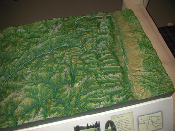
Lolo Montana is at the upper right, where the Expedition turned 90º West.
The new Visitor Center - right on the MT/ID State Line.
I reach Lolo Montana and turn left for Missoula, it's just up the road 10-12 miles and wend my way through traffic and past a Chinese restaurant I found two years previous.
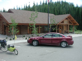
I ate well before rolling-out for RT#200 - which I pick-up when I jump onto IS # 90. But, just four miles later Rt#200 leaves the Interstate for Lincoln and other points East. Lincoln sits in the mountains and it's a pretty ride and pretty country; it's the little community that the Unibomber put on the map.
And, while I've stayed in Lincoln before, I was eager to do so again as the City has a community park that had (operative word - past tense) some amenities I needed.
I found the park as before, even found the same convenient campsite available, and still only $6/night. However, the pay telephone I was counting on using had long since been removed and cellular service was later found to be piss-poor. Pat'n I got to say 'Hello' and the connection was lost. Oh well!
I had a bottle of fermented grape juice and was enjoying that while writing postcards when I looked-up to see a west bound BMW rider (GS model) loaded with camping equipment roll into town. I was too far away to hail and went back to my cards.
A half-hour later this same rider comes rolling-up behind me. We were pleased to see each other.
Richard Patenaude is his name, a heavy equipment operator from a place in Illinois that's south of Chicago. I'm told that he's then on his way to Alaska, having trucked his motorcycle into Montana so as not to have to ride the Midwest. His immediate plan is to visit the BMW dealer in Missoula and then turn north. I shared my campsite with him and we broke camp early in the morning before departing Lincoln in opposite directions2
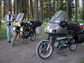
Packed, ready for breakfast - Lincoln MT