Lima Ride '05 - Chapter #2
Lincoln Montana to Brainerd Minnesota
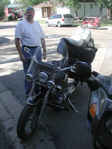
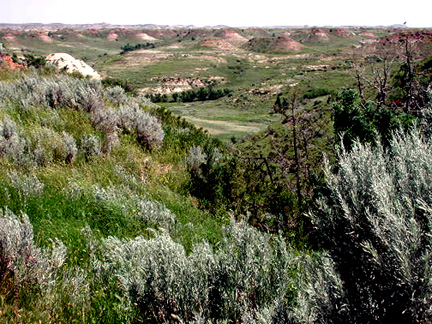
Rolling eastward it was my intention to find a State Liquor Store, and the first city of any consequence along my route was Great Falls. This is a clean town, as was Missoula, but sans the trees that abound in the latter.
I've concluded that states with state-run liquor stores go out of their way to make them both non-descript and otherwise hidden from popular traffic flow. Great Falls was no exception. I found the liquor store; it was off the major traffic route a hundred yards'er so, and across from a huge Target store. That, at least, was a convenient arrangement for me. I wanted to procure some insect repellant, though insects were not yet a problem, nor were they throughout our travels this year; also wanted some batteries for the camera. I used the pay phone in the lobby, with my now-reprinted phone card, to call Pat. Luckily, I caught her at home. While in Payette I noticed that I was running out of minutes on 'our card' and asked Pat to order-up some more minutes. Imagine my reaction to hearing that I had 2074 minutes for my call. Pat explained it was an automated re-order system via credit card and it didn't go the first time, so she did it again! An MCI design by chance?
Pat told me of 'plumbing problems' at home and what did I want her to do about it? I knew what the problem was, also knew the 'fix'. This happens about every fifteen years without fail. The sink drain line has very little 'drop' but has a readily accessible clean-out in the basement, a half-hour job for me, but several hundred $$'s for a plumber. Could she hand-wash in the tub for the couple days she was going to be home and I attend upon our return? She could! YEAH!
I was soon back on the road and rolling-out for the true 'Big Sky' country. I gassed at Stanford at Noon. $2.59.9 for super. I was then getting 38.9 MPG.
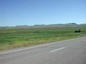
Entering Big Sky Country
Just east of Stanford is the ghost town of Moccasin from which I took some great pictures two years previous. The town dried-up with the '29 Depression. I was down the road another 10-12 miles passing the directional sign for Hobson when I noticed a small, handcrafted sign for Gramma Ruby's Cafe.
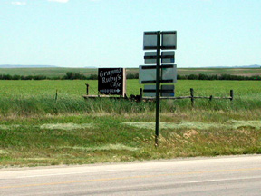
The sign that caught my eye! Gramma Ruby's
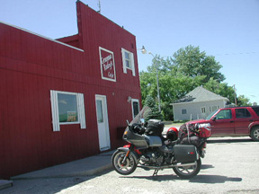
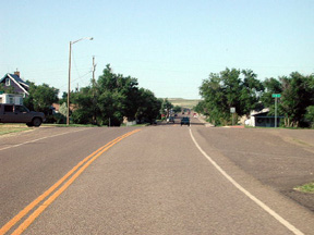
Downtown Hobson
I pulled a U-turn and wound my way through some long -abandoned grain elevators for Gramma's. Neat place! Everyone knew everyone else and everyone sat at a U-shaped lunch counter. Great milkshake! (I took Pat here on our return home but more on that later.)
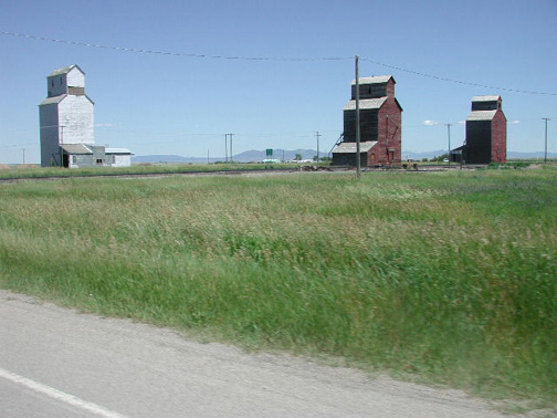
These Hobson MT elevators are all very dilapidated. These sit between Hobson
and Hwy.#200.
Hwy #200 becomes relatively 'featureless' in western Montana and I rolled into Jordan for my next gas, having 'flown' pretty low in between. Jordan is about dead-center for that area of Montana that's yielding some of the spectacular Dinosaur discoveries, particularly those of T-Rex. I was fighting some crosswinds getting
into town, mileage dipped to 35.7 MPG. I pressed-on.
During my previous foray into this country I met with the Mayor of Circle Montana (where I was offered the Interim Chief of Police's job), and learned they were faced with a water crisis. Their wells were contaminated with bacterium that was proving to be very costly to remove. I learned back in Jordan that they too had the same problem and the Rx had been chosen. Water was to be piped to these communities (and others I assume), from the Fort Peck Reservoir, about 80 miles distant. I snapped a picture of downtown Circle on my way through.
Downtown Circle Montana
At Circle I opted to take Hwy#200-S instead of Hwy# 200. Why? Well, it WAS a road I'd never been down for one thing, secondly it was a route that would take me past Teddy Roosevelt National Park -South, and I'd visited the northern portion my previous trip. Hwy #200 = Hwy#200 so it wasn't out of my way. Hwy. 200-S would require a little Interstate travel (IS#94), oh well!
It was 7:56 PM local time when I had camp set at Makoshika State Park, which abuts Glendive MT. This is right on top of the North Dakota border (35 miles away), and 451 miles from Lincoln Montana. Nice setting, in 'badlands', water, but no showers and even I was having some trouble sitting 'near myself'. I stunk! However, I had cigars AND liquor so all was not 'lost'.
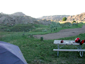
Camp at Makoshika Sate Park, Glendive MT ('Badlands Country').
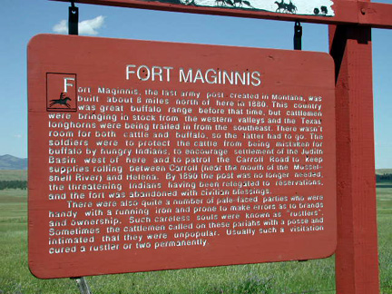
When riding Montana, pause to read their historical markers - some are humorous reading. Note the last paragraph.
I cleared out of Makoshika State Park in the morning and rode into Medora North Dakota in search of gas. My notes tell me I did use that 2nd reserve another time, like here! I paid $2.47.9 for 5.3 gallons and got 35.45 MPG; while gassing-up another road-rider pulled-in and we struck-up a conversation, agreeing to 'breakfast' together. Medora is also the entrance site for Teddy Roosevelt National Park -South so I wanted to stay in town a while anyway.
My newfound friend, Curt Wood, turned-out to be an Iron Butt Contender1 and otherwise a high-school math teacher from the Austin Texas area. We had a nice
visit.
Curt Wood
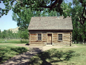
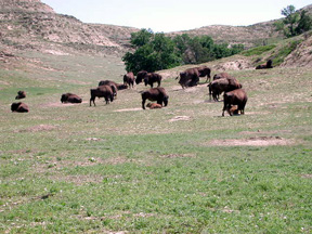
Teddy Roosevelt National Park -South Unit has TR's ranch cabin. TR first came to the Badlands Country to hunt Bison but fell in love with the country and subsequently bought two very large ranches in the area. He was here long before his Presidency. His brand was the Maltese Cross and he formed the first 'Cattleman's Association' in this country. They assert that it was here that TR formed his strong feelings for conservation and preservation of lands for subsequent generations. His first 'ranch cabin' has been preserved and moved/reassembled six times over the subsequent years2. And, while the cabin is located back on the original lands, it sits some six miles from where originally constructed.
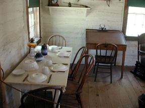
Maltese Ranch House Sitting Room w/ TR's Desk
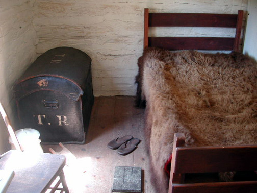
TR's Bedroom
TR's 'Badlands'
Indian 'Firewood' in the Making
I toured TR's National Park South and concluded that I enjoyed the North Unit more.
Leaving Medora I rode the Interstate EB and past the US #85 intersection, which was Rt.#200 at that point. Having seen that country and Killdeer previously, I opted to turn 'up' (go North), State Hwy #8 through Marshall, with a plan to break in Marshall. Ha!
Since my map was printed Marshall all but blew away!
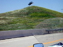
Large Cowboy Silhouette Dominates Looking the other way, abandoned Post Office
Marshall, North Dakota
It was time to roll east. Hwy #200 is straight, but the country undulates and riding the highway is much like doing a 'kiddy roller coaster'. There are lots of interesting farms and lots of agricultural implementia on the road to pass. ND has water, lots of it too! The highway would frequently dip'n swerve to weave a path through shallow lakes and marshlands. I saw a lot of ducks and chucker while running across North Dakota, but no Antelope were seen while EB. I usually see lots of Antelope in North Dakota.
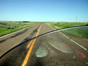
Those are 'dips' in the distance.
I got back onto ND #200 EB and shortly came to a curve but had some misgivings about my vision/sanity. (That'll bring some feedback for sure!) What was I looking at? A barn built by a demented farmer? Was it a work of art? Tell me you wouldn't have done a double-take yourself. Naturally, I made a U-turn and trespassed on abandoned private property to take these pictures.
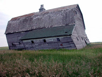
This barn will not take much of a snow load! Note that the windows on the R are still intact.
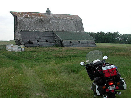
Okay! So I left the parking light 'on', so what! It's on the side-stand.
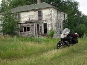
The barn's farmhouse has faired somewhat better.
Wow! What sights this collection of state highways, all numbered '200' and connecting one another, have to offer. I was now enroute for Pick City, a community in which I have fond memories from my previous junket. I gassed here, along the banks of the great lake, Lake Sakakawea. The lake is about 150 miles long and is formed by the earthen dam that blocks the Missouri River at Pick City. The dam? Garrison Dam.
I had planned to dine in Pick City and did so, gassed too! 40.2 MPG over the previous 172 miles. Expensive? $2.49.9/gallon for 'super' mind you. I didn't then know where I'd spend the night. However, on leaving town a sign on my left announced the presence of Lake Sakakwea State Park. Okay, it was expensive, or was it? It was $13. /night for 'primitive' camping but I was still eligible to use the showers in the 'expensive camping areas'. Cut costs.....you bet! I found my way to 'Thirteen Dollar' primitive camping okay.
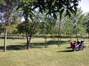
It was a huge area of cut grass, tables and fire pits that included about 60 sites.
Crowded? I was the loan occupant of this expanse of real estate.
The park was doing a brisk business during all this. Lake Sakakawea is supposedly prime fishing and fishing boats were otherwise everywhere. I set my 'lonely camp', gathered my stuff and for the first time in my life, rode a motorcycle in flip-flops to find a luxurious shower. Boy that was a good one! It was time to head back to camp, set the towel to dry and address some equipment repairs (air-mattress), and postcards. I took another self-portrait too!
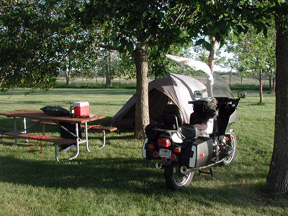
Crowded 'Primitive Camping' Post shower camp
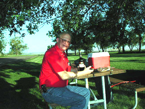
Ah yes, Swiss Army Knife has a corkscrew.
It was here that I called both Pat (I'm to 'check-in' daily), and my riding partner, Marvin Bohn of Brainerd MN. Pat's happy! She has an excuse to dine-out (plumbing problems you'll recall), and a ride to the airport so as to rendezvous with me in Columbus, Ohio for the rally a week hence - the pretense behind this whole ride. Marvin, and his lovely wife Carol, have given me the green light to 'land' on their doorstep whenever I get there.
The hot wind dried my towel (seen in the above photos), in no time and I brought it into the tent that night. Also, since I was set-up on cut grass I chose not to use a ground cloth under the tent and staked the tent, given the breeze. And you doubted there was a God? That night I had a thunder, lighting and a rain event like nothing I've ever experienced previously. For the first time I heard 'rolling thunder' - something hard to describe. You'd hear a 'boom' coming from what sounded like the upper lake, a hundred miles away. Before that first 'boom' could die down, another, louder, then another and another, each getting louder, and seemingly, closer. Of course lightening during all this was illuminating the interior of the tent. There was some wind early on, but by the time the rain mixed with all this, the wind had subsided.
Given the temperature, time of year, etc., my equipment dried-out early in the morning and I was back on the road shortly before 11:00 am. I took a couple of pictures of Garrison Dam on my way across, but then 'twisted the wrist'. I was about ready for a break when I pass this trucker, stalled along side the road and headed my way. His hood was up and it was HOT! Again, I u-turned and came back around to check. It turned out that he was employed by a beverage supplier out of Bismark and at the moment, was the shift supervisor as his boss was on vacation. The fan bearing failed on his rig and the fan blades had moved forward and chewed-up his radiator. Yes, he'd already called for a hand-off to another truck, and a tow. We shared a smoke'er two and chatted it up for a half-hour or so. I supplied him with a cigar and a cold drink before I turned around and continued on my way. Nice fellow! A motorcyclist in his own right; he was particularly interested in the BMW as few are found in the 'heartland'.
I was back on the road and in search of a 'beanery' I'd found two years previous, one that was open on the 4th of July 2003 and run by two LOL's (little old ladies). Try as hard as I did, I couldn't find the place - it served-up some great peroski and hand-made pies. Damn!
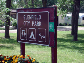
Needing a break, one with shade mind you, I pulled off the highway in the little community of Glenfield for a stretch. Their park was immediately adjacent the highway and like so many of the little community parks in this part of the country, the traveler was welcome to camp for the night.
It was about forty minutes later that I pulled into Cooperstown ND for gas, it'd been 172 miles since Pick City and my mileage was back up to 43 MPG (must've slowed down some).
Still looking for the beanery I never found. And, by the time I reached Hillsboro ND (almost to the Red River of the North, the 'state line'), I was famished and found my way to the Water Wheel Restaurant. I treated myself to a beer and dined at the bar, this on a 12 oz., New York steak. The people at the bar were all employed at this huge sugar beet plant I passed on my way into Hillsboro. We enjoyed each other's company.
I crossed the Red River into Minnesota as I should have two year's previous, only then I was re-routed due flooding. I rolled through Ada, the first Minnesota town of any consequence and recall that two years previous I was on almost two inches of really messy fine mud and slime, but not this year! I was having fun, taking in all the sights when - DAMN! There was a police car at the side of the road and all lit-up. I figured I'd been nailed by radar and pulled-over behind the cruiser. The officer, nice young fellow with two years in the 'business' apologized to me, he'd finished a traffic stop and was doing the paperwork but left his lights on. Well, I introduced myself, packed my briar and we talked for a good half-hour about police work, his experiences and hope for the future. I told him I thought he'd be ahead of the game to set his sights on Minneapolis or St. Paul and why. I gave him a San Francisco Police shoulder patch before I departed, explaining the old Spanish embroidered thereon, Oro En Paz, Fierro En Guerra, translated it reads 'Gold in Peace, Iron in War'. Whew!
No ducket for me!
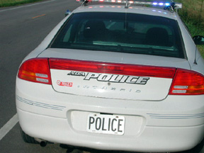
Ada Police Car Lit-up!
Staying true to form, I rode-on thinking I may make my Brainerd host's house that evening.
I was still traveling Rt#200, only now it was Minnesota '200'. Light was starting to fade
when I happened upon a gas station a couple hindered yards out of my way at
Kabekona. The station was then closed, but the pumps un-locked and operable with a credit card. I gassed-up. I had 184 miles on the tank and must have been cruising faster as my mileage dropped to 37.75 MPG. There was a pay phone there, better call my hosts and check on the 'welcome mat'. Line 'busy', tried again, 'line busy'. After the third try I call Pat, 'line busy'. There's a pattern here! I try Pat after another smoke. She's been on the phone with Carol Bohn, my riding partner's wife. Pat tells me I'm expected, great! Yes, she'll call back, advise of my location and that I'm coming in. It was time for me to scoot.
I left my good friend, Routes numbered 200 just outside of Walker Minnesota and picked-up MN Hwy #371, upon which my hosts, Marvin & Carol Bohn reside. I rolled-up to the Bohn house at 11:25 PM, having covered 443 miles since Pick City; 2243 since home.
Bohn Residence